Off-Road.com persists in insisting that you get off your keyster and into the dirt on a regular basis, because, with a little attention to tires, maintenance and a dash of technique, the bone-stock truck in your driveway can take you a lot of places. Off-roading is frugal family fun necessary mods are inexpensive, the on-trail pace is reasonable, the techniques are easy to learn, and throw in a sleeping bag and a few hot dogs and youve got an overnight that might get the whining horde to clam up for a while and its right in your backyard.
There is a lot of off-roading to do in the Big Bear/Lake Arrowhead area good high-mountain froading with trails that are alien to the typical sand/rock/sand experience folks expect of SoCal. Some trails require more truck than others: Gold Mountain Trail one of the most entertaining in the hills in Southern California is a sporty piece of road that can put a well-equipped truck to the test. Its a step beyond a bone-stock commuter but totally doable if you have a brain and the right machinery.
.")
Gold Mountain Trail, San Bernadino National Forest (Big Bear)
Pros:
- Killer selection of trail surfaces mud, rock, roots, scree, even snow.
- The trail is tight enough that you cant fake it everyone needs rock skills or a few skid plates.
- Variety of rockfield styles tumbledown granite, dirt/boulder conglomerate and rock-drop/ledge-climbs provide excellent skills-improvement for burgeoning trailfans.
- Good mud and moisture on the snowy side means every trail technique you thought you had becomes a new challenge.
- Long enough for a daylong photo run, short enough for a morning tough-guy sprint.
- As-far-as-you-can-see views of the San Bernadinos, San Gabriels, Santa Anas and San Jacinto Mountains, with the Mohave laying there like a big sandy bonus.
-Countless places with proper roofs to stay in in the area, so you can parachute in for a day of rock-bonking and bookend it a warm bed and decent high-mountain beering.
- Plenty of camping in the same area, if you prefer to keep things low-buck and strategic.
- Links to the Holcomb Valley Trail (3N16) ridge route and its associated awesomeness.
- If you finish this one, you can brag about doing one of the best trails in the Big Bearea.
Cons:
- Challenging enough that your kids might puke.
- The trail is tight enough that you cant fake it everyone needs rock skills or a few skid plates.
- Not a trail for beginners or poseurs; check your ego at the road.
- Deceptively easy to get in over your head if youre newb, follow someone who isnt.
- Big trucks will suffer, and full-size long beds are not recommended.
- The top of Gold Mountain Trail ends in Holcomb Valley, so have a plan for your exodus.
- If you make this run in the off-season, know that not all of the trails are open.
- As with most things in California, the state has its fingers in the till: youll need to buy an adventure pass if you plan to have one overnight.
 peels off to the south. To someones credit, its marked well.")

Hard Points: What, Where and How
Trailheads: the vaguely north-southbound Gold Mountain Trail (3N69) has two ends: the northern end at Holcomb Valley Trail (3N16) in eastern Holcomb Valley, and the southern end at pavement on the northern route out of Big Bear (State 18) around Baldwin Lake. That southern end of 3N69 is a hair short of two miles east of the northern T-intersection of the lake cutoff shared by State 18 and 38, north of Big Bear City (and right across from Big Bears scenic sewage treatment plant along the southern edge of Baldwin Lake).

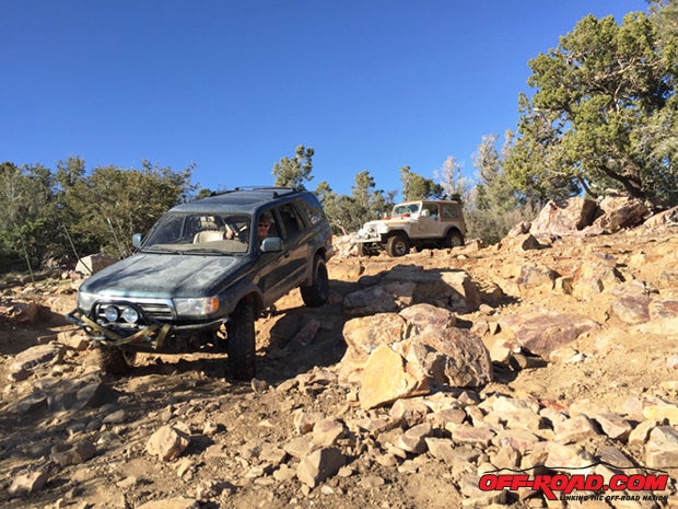
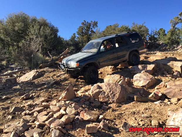
Terrain: rough dirt two-track, with significant rock assortments consisting of ledges, jumbles and steps of seriously inconsistent nature. If youve driven higher-mountain trails in the Rockies, its more akin to that. Significant vertical features. Narrow in spots. The northern (and less sunny side) of Gold Mountain is much more mud, ditch and root-intensive, with many switchbacks and off-camber trails knotted through mountain pine. When climbing from State 18, it becomes gradually more difficult; from Holcomb Valley, youre in the thick of it pretty quickly.
.")
Vehicle Requirements: augmented ground clearance, four-wheel drive and appropriate rock-friendly rubber are recommended. Vehicle with steps will not have them by the end, or will wish they hadnt. Prepare to chew on sidewalls and possibly on wheel lips. Low-range will probably be necessary if you dont have a crawly first gear, though we watched skillset triumph over limited equipment on several occasions. A rear locker was useful but not in the rocks we needed it for several significant snow banks. Bush rash is likely in summer. Leave longer trucks and fancy SUVs at the trailhead.


Skill Requirements: if youre not skilled when you begin, you will be by the end. Find a leader with a clue, and if youre too cool to bother with trail awareness and truck-control, dont bother with this trail. An advanced beginner will learn a lot, and an advanced off-roader will have a great time. There are a few trail spots that will make you wonder if youre in over your head, but a good spotter and a winch can fix most anything.
.")
Author and friends equipment: third-gen 4Runner with more miles than Voyager 1, four-wheel drive, rear locker, custom three-inch spring lift, Goodyear MT/R Kevlars at 20psi; as well as a small-block and clutch-equipped CJ-7 on 33-inch Goodyear Duratracs with a four-inch BDS lift, and a small-block six-speed FJ-40 on 33-inch Adventuro M/Ts with three inches in the springs.

Big Bear/Lake Arrowhead Area Ideal for Overnighters and Weekenders
The Big Bear area the same thats got snowboarding when theres snow also has a very good selection of interesting/difficult/entertaining trails for trucks, though it is not exactly in our backyard. We San Diegans had to drive a whole 2.5 hours to get there. However, this area is take-a-day-off convenient and overnight-easy for anyone in San Diego or Los Angeles, plus, you can drink the water. In a story published last month on Off-Road.com [http://www.off-road.com/trails-events/trails/big-bear-offroad-jacoby-canyon-trail-54405.html], we explored Jacoby Trail and its Kalifornistan-standard sand/pine/scrub/rock character, but Jacoby is incongruous with the bulk of the flora and fauna on the mountains surrounding Big Bear and Lake Arrowhead the bulk of this area looks like big mountain trails near places named Buena Vista and Ouray. Big trees, vertical rock and dense boulder fields, and the seriously discombobulated trail features that make off-roading interesting, with altitude gains that render the view worth your time... Big Bear is worth a weekend or, at the very least, trimming a Friday off your work week for a four-wheeled adventure.


Now, while many of good trails in the Los Angeles/San Diego metroplex have been blocked by taxpayer-funded No-Men wearing state and federal uniforms, the Big Bear/Lake Arrowhead area (the San Bernadino Mountains east of Los Angeles) offer a surprisingly unfettered network of trails and an excellent selection of terrain. You owe it to your free-roaming self to try a few on, because these trails have everything from daily-driver easy to rock-and-drop difficult. Get involved in local trail-access advocacy groups to help keep these trails open in the face of groups like the Sierra Club and companies like REI and Sierra Nevada that want to close them down.

Excellent Variety of Off-Season Terrain and Conditions on Gold Mountain Trail
Fun! This is a good trail satisfying without being ridiculous, popular without being crowded, challenging without requiring you to winch all over the place (or at all, if youre good enough), with room enough to play without detracting from its relative remoteness.
If youre going to head northbound on Gold Mountain Trail (pictured in this story), the route is deceiving: the scale of obstacles increases gradually, and youll find yourself in more difficult terrain than spots lower on the mountain would suggest. That said, if you are ready to up your game as you climb, Gold Mountain provides an increasing level of difficulty that makes it more and more interesting as you go.
The headed-south route on Gold Mountain Trail (3N69) peels off from Holcomb Valley Trail (3N16) as pictured, about 3/10-mile west of the top of Jacoby Canyon Trail (3N61). A large number of other trails branch off Holcomb Valley further along, so your ingress and egress to this point is not limited to just Jacoby Canyon. That said, many of these other access routes to Holcomb Valley are easier than Gold Mountain Trail, and do not serve to gauge of its difficulty.

Coming from the north, Gold Mountain Trails conditions rapidly assume their most interesting state, with loose and wet dirt combined with significant tree roots and slippery ledged switchbacks. The tree roots are a special kind of tricky, made more so by the presence of snow. A large portion of the moisture was from snowmelt you really need to try this trail off-season, as we did but even without the runoff, trail surface was narrow and technically interesting. The snow alternates between making the trail harder slippery, inconsistent, impossible to gauge depth and easier filling holes, bridging gaps between rocks, holding rubble in place.
 and lusty mountain terrain. Plan to picnic while youre up here, or at least break for munch and sips.")
The unmelted patches of snow and associated runoff and puddling made the northern approach to Gold Mountain a unique challenge. In heading southbound, we were in the shadow of Gold Mountain for the first half of the run, and there were noteworthy snowdrifts to contend with. These proved the most challenging trail feature as they did weird things to traction that would have been a cinch in wet or dry situations.
Gold Mountain, whats peak is 8235 feet above sea level, roughly overlooks the highest point on the trail itself, a flattish, slightly wider area of trail where picnicking would be well-planned. The terrain changes character quickly beyond this, shifting from damp, darkened dirt, rocks and trees to sun-blasted rocks and serious dropoffs, with larger rocks dominating trail features.
 begins at this point, just off State 18.")
The southern face of Gold Mountain, which the trail roughly diagonals across from west to east (headed downhill, as we were) was a much different creature than the shaded northern side. Heavy rock fields not untraversable, but substantial (see the pictures in this story) dominate, so youll be crawling as much as driving, and probably spend time in low-range. We listened to a lot of desert metal on the way down the slow, bluesy pace of Kyuss and Fatso Jetson is a good leveler when attention paid is at a premium.
Technique for rocks and crawling is a mixed bag: basics like tire pressure and maintenance standards are unavoidable everyones got to. The flipside of that is the dead-to-nuts requirement of knowing your truck, and how you approach an obstacle depends on that relationship. The resto-modded CJ-7 Renegade pictured in this story is small-block powered; it has the torque to make several different gears useful when climbing, and the engine drag to enable almost brakeless down-obstackling (get it?). The 4Runner is slightly heavier, longer and relatively underpowered, and engine drag is limited. However, it has big boy Tundra brakes [http://www.off-road.com/trucks-4x4/tech/project1620.html], so the driver can essentially ride them all the way down a mountain and the steep side of big rocks, while improved gearing means it can crawl uphill in high or low, while the CJ lives in low going uphill. Basic technique is nice, but vehicle-dependent skills are necessary, which means one thing: experience.

Some Big Bear History We Thought Should Be Included
Gold Mountain and its trail overlook Baldwin (sometimes dry) Lake and Big Bear Lake. The lake was named for notable rich guy Elias Lucky Baldwin, who expanded gold mining in the Big Bear area on whats now Gold Mountain with ramped up excavation and a series of stamping/processing mills (and was probably responsible for the PR campaign that drew workers into the area to support his mine).
Outside of the froading, we did a lousy job touristing the location, and apparently missed mill remnants, tailings and a cemetery. At different times, two towns and expansive mine workings supported the Gold Mountain Mining Companys endeavors, and we saw very little of them. We looked for offshoots but not very hard there were a number of fence-lines that crept up on us from the side, so its likely theres still active use (or active residence) of property along the trail.
References:
Backcountry Adventures, Southern California; Peter Massey and Jeanne Wilson, Swagman Publishing 2006
Big Bear Backcountry Adventures; Don Alexander and Cindy Morley, Backcountry 4x4 LLC 2014
BigBearHistorySite.com; SEO Company and Daily News 2008
California Road & Recreation Atlas; Benchmark Maps, Benchmark Maps 2007
Off-Highway Vehicle (OHV) Guide; Southern California Mountains Foundation and Yamaha Motor Corporation, 2014
|
Off-Road.com Newsletter Join our Weekly Newsletter to get the latest off-road news, reviews, events, and alerts! |
Follow @Off-Road
 Your Privacy Choices